In Franklin County’s scenic hills, Antietam Creek gurgles to life. Its waters flow south into Maryland for 42 meandering miles before emptying into the Potomac River. The creek’s name is thought to derive from an Algonquian phrase meaning “swift-flowing stream”. In the present day, Antietam Creek symbolizes much more than crystal-clear water. Many local businesses and organizations are named in tribute to the stream’s cultural distinction. The waterway is also known worldwide for a monumental battle fought during the American Civil War. The word Antietam evokes both natural and historic nostalgia.
In bygone days of 1800’s transportation, Antietam Creek could be an obstacle to reliable travel when local farmers drove their livestock and produce to market. Wooden bridges were common in that era. But they often needed renovation or complete replacement every few years. Around 1820, a new structural type emerged as a longer-lasting alternative: the stone arch bridge. Local quarries were bursting with limestone and other native rocks, offering a plentiful supply of building materials.
The arched design was not only graceful and pleasing to the eye, but also served a practical purpose. The lovely curves partially transferred the weight of a crossing load to anchored abutments on each side. Luckily, there was a pool of skilled artisans working in southern Pennsylvania and western Maryland who eventually built this type of bridge. Their finished handiwork is still evident almost two hundred years later.
Many of those original Antietam Creek stone bridges remain, and some still ferry modern traffic. These rugged structures are a time-capsule revealing primitive travel modes, rustic beauty, and an extinct architectural form. Most of the bridges are located in Washington County, Maryland (17 cross Antietam Creek there), and for a curious traveler they offer potential portals to discovery along back roads and rolling farmland. Here are three local stone bridges that cross Antietam Creek.
WELTY’S BRIDGE
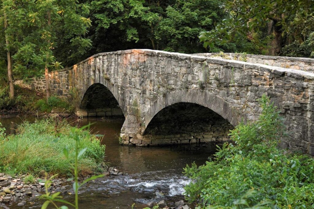
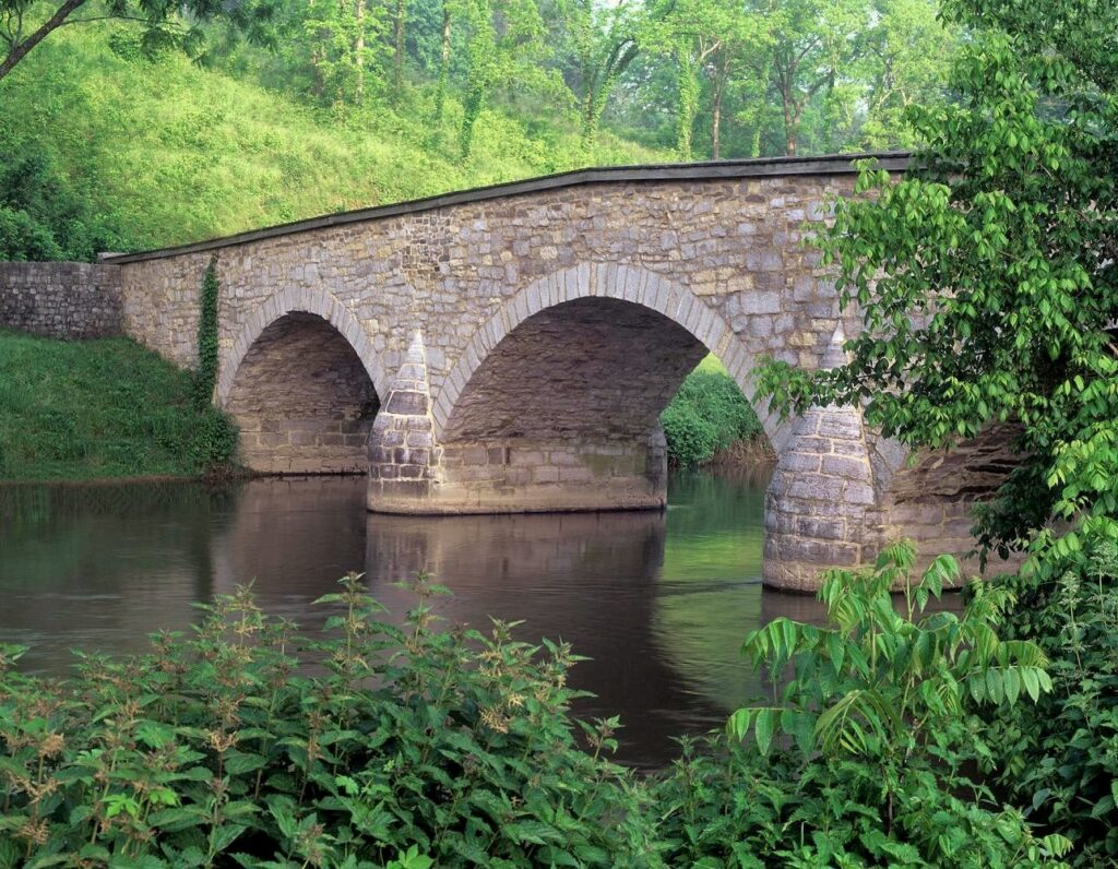
The east and west branches of Antietam Creek (often called the Little Antietam) flow through opposite outskirts of Waynesboro like a natural set of parenthesis. After the eastern branch passes the lovely Renfrew Park grounds, it is spanned by Welty’s Bridge. The aptly named David Stoner built this 137-foot-long limestone structure. The twin-spanned Scottish-style bridge was completed in 1856.
Like many other stone bridges in the area, Welty’s Bridge was named for a nearby landowner. Around 1798, Mr. Welty harnessed the Antietam’s flowing water to power his mill. He also wet the whistles of locals by distilling rye and malt whiskey. The picturesque landscape around the mill, with the bridge stationed a stone’s throw away, became a Waynesboro landmark, like a scene in a Currier and Ives painting.
Welty’s Mill eventually vanished, but the bridge still stands. Welty’s Bridge carried motor traffic until the 1980’s, when a modern but featureless concrete replacement bridge was built nearby. The contrast between the two structures is a striking example how evolving transportation needs and rising material
costs have dulled bridge design. Sadly, it’s no longer practical to build artistic stone spans like Welty’s Bridge. The Waynesboro Historical Society cares for the bridge and supervises its ongoing restoration. Resurfacing and repointing has begun, but additional fundraising is still necessary to complete the project. Welty’s Bridge was listed on the National Register of Historic Places in 1983.
LEITERSBURG BRIDGE #2
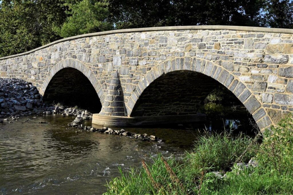
In Maryland, John Weaver became a well-known master builder of stone arch bridges. He supervised the construction of Leitersburg Bridge #2, a short distance north of this small hamlet. Originally called Strite’s Mill Bridge, it is now simply called the #2 bridge since the first structure was swept away by floodwaters. The area surrounding the bridge rises steeply on each approach, and is prone to regular high-water spells. But this second bridge has remained intact since 1829. The Leitersburg structure was renovated in 1982 and appears in excellent condition. The integrity of the materials, design, and craftsmanship are wonderfully preserved in this handsome double-arched span.
Unlike Welty’s Bridge, Leitersburg Bridge #2 still serves its original purpose. But the one-lane humped roadway requires motorists to pay close attention and yield to approaching traffic. The idyllic surroundings are a wonderful distraction that harken to a simpler age. Approached from the east, a park-like patch of greenery hugs the creek bank, and a nearby dirt lane leads to a rustic red barn. Fields of corn and other crops flourish on summer hillsides. Unfortunately, no public parking is available near the stone bridge, so to respect private property it’s safer to enjoy this landmark from a modern vehicle.
BURNSIDE BRIDGE
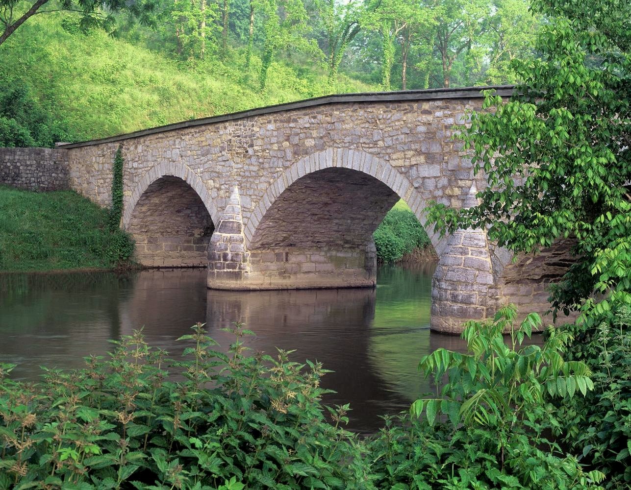
This historic structure is likely the best-known stone bridge in the entire country. Burnside Bridge was originally called Rohrbach Bridge, but a Civil War General’s military exploits later altered the name. Located in Sharpsburg, Maryland, Burnside Bridge was built in 1836; also by John Weaver. Little notice was given to this three-arch span until 1862. On September 17th that year, an epic fight took place on this bridge during the Battle of Antietam.
On lower ground next to Antietam Creek, 500 Georgia Confederates stood poised to defend the bridge. Occupying the high ground, 14,000 Union troops massed under General Ambrose Burnside’s command. Burnside cut a dashing figure- the flamboyant thick whiskers growing on his cheeks would later lead to a new fashion term created for Burnside’s unique facial hair: now known as ‘sideburns’.
Burnside’s troops attacked the bridge once and were repelled. The Yankees charged full-throttle a second time and were beaten back into another retreat. Finally, on the third assault, the Union’s superior forces captured the stone bridge. The battle of Antietam was a tactical victory for the North. But the price paid by both sides was a national tragedy; that fierce fight remains the most gruesome day in American warfare with over 22,000 casualties. Local lore says that Antietam Creek ran red that day.
Today, the National Park Service protects and interprets the battlefield and Burnside Bridge is a pedestrian-only crossing. The 125-foot bridge is a beautifully preserved centerpiece on the bucolic landscape. A visit to rural Sharpsburg transports visitors back to an earlier time when Union and
Confederate soldiers walked these fields. In 1937, on the battle’s 75th anniversary, a United States half-dollar was minted with a rendering of famous Burnside Bridge forged on the coin.
***
These three bridges are a small sampling of the area’s stone bridge heritage. For more information about the arch bridges in Washington County, Hagerstown’s website offers suggestions for further exploration (visithagerstown.com). On the northern side of the Mason-Dixon Line, Welty’s Bridge preservation efforts can be aided by volunteering or donating to the Waynesboro Historical Society (waynesborohistory.com).